- Alumni
- Science
- Graduate
- Agriculture
- Research
- Featured
WT Graduate to Present Significant New Research into Playa Lakes at National Conference
Copy by Chip Chandler, 806-651-2124, cchandler@wtamu.edu
CANYON, Texas — A recent West Texas A&M University graduate will present groundbreaking research into methods to more closely analyze a crucial feature of the Texas Panhandle ecosystem — playa lakes.
The High Plains area is home to tens of thousands of playa lakes—shallow, circular wetlands that Texas Parks & Wildlife calls “arguably the most significant ecological feature” in the region.
“Mounting evidence points to playa lakes as a critical recharge source for the Ogallala aquifer,” according to Texas Parks & Wildlife. “Playas filter and recharge as much as 95 percent of the water collected in the southern portion of the aquifer.”
 Hannah Tripp, who earned her master’s degree in environmental science in July 2021, will present her research into how satellite data can be used to better monitor water levels in the High Plains area’s playa lakes Oct. 27 at the third Playa Research Symposium in Kearney, Nebraska.
She previously published her research in the journal Water on July 26 and presented it at the European Geophysical Union’s annual meeting in April 2021.
While at WT, her research was funded in part by a Killgore Graduate Student Research Grant through WT’s Sponsored Research Services.
Tripp, who currently works as an environmental compliance specialist at Georgia Environmental Protection Division, partnered on the research with Dr. Erik Crosman, assistant professor of environmental science; Dr. J. Brad Johnson, assistant professor of biology; Dr. William Rogers, professor of environmental science; and Dr. Nathan Howell, the Bell Professor of Engineering and associate professor of civil and environmental engineering.
“Satellites are the best way to monitor them in a cost-effective way,” Tripp said. “It would not be realistic to have people repeatedly fly or drive all across the Plains. My research demonstrated that it is possible to monitor these playas on weekly scales for the first time from satellite. Earlier studies looked at them on yearly scales.”
Tripp used data compiled between September 2018 and February 2019 by the freely available Sentinel-2A and 2B satellites from the European Space Agency, which can detect water levels by utilizing 13 image sensors that measure visible and infrared light.
Playas are closed basins, meaning that water can only leave by evaporating into the air or percolating down into the soil, Tripp explained. Depending on the types of clay and underlying rocks, where and how much recharge comes from the playas varies.
“One thing that my research demonstrates is that we could potentially look at rates of recharge by seeing how much the playa water decreases over time from satellite,” Tripp said.
Additionally, playa lakes are an important source of water that sustains a number of species, including amphibians and birds.
“Texas is located along the Central Flyway, one of the four main bird migration routes in North America. Wet playas provide a place for migrating birds to rest and eat before continuing their journeys,” Tripp said. “Birds are more likely to nest successfully if they are able to utilize playas as stopover sites during spring migration.”
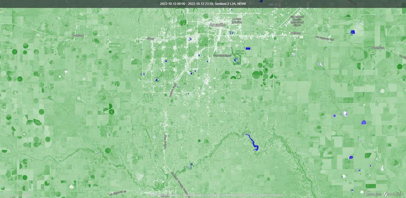
Photo: Satellite imagry from the Sentinel-2 taken Oct. 12 shows playa lakes around the Amarillo area, as well as Lake Tanglewood. The imagery contains modified European Space Agency Copernicus Sentinel data processed by Sentinel Hub.
Crosman said Tripp’s use of new, high-resolution satellites helps scientists gain insight into thousands of playa lakes that they were unable to effectively monitor in the past.
“These lakes had been neglected because they were either too small or too infrequently observed,” Crosman said. “Given the importance of playa lakes to our region, Hannah has certainly broken ground on how to use measurements from space to help understand our regional playa lake ecosystems here in West Texas.”
Tripp, originally from King George, Virginia, earned her bachelor’s degree in biological sciences from Virginia Tech University. She said she chose to pursue her graduate degree at WT because of its significant research opportunities and caring professors.
Addressing regional challenges as a Regional Research University is a key component of the University’s long-range plan, WT 125: From the Panhandle to the World .
That plan is fueled by the historic, $125 million One West comprehensive fundraising campaign. To date, the five-year campaign — which publicly launched in September 2021 — has raised more than $110 million.
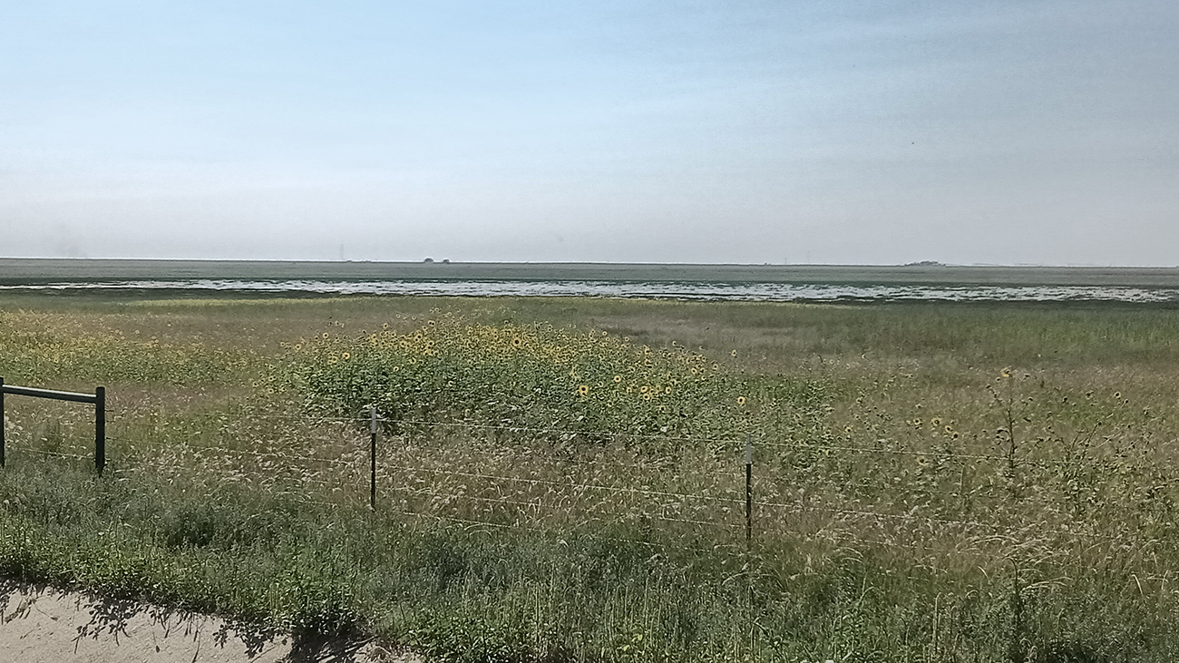
Photo: This playa lake, located about 15 miles west of Canyon on Farm-to-Market Road 1062, is one of thousands that can be studied more closely through the use of satellite imagery, accordign to new research by a West Texas A&M University graduate.
About West Texas A&M University
WT is located in Canyon, Texas, on a 342-acre residential campus. Established in 1910, the University has been part of The Texas A&M University System since 1990. WT, a Hispanic Serving Institution since 2016, boasts an enrollment of about 10,000 and offers 59 undergraduate degree programs and more than 40 graduate degrees, including two doctoral degrees. The University is also home to the Panhandle-Plains Historical Museum, the largest history museum in the state and the home of one of the Southwest’s finest art collections. The Buffaloes are a member of the NCAA Division II Lone Star Conference and offers 14 men’s and women’s athletics programs.
—WT—