

Does the Ogallala Aquifer Recharge in the Southern High Plains?
Author: Carla Eichler, PhD, Department of Life, Earth, and Environmental Sciences, West Texas A&M University, Canyon, TX
Date: Sep-01-2026
The Ogallala Aquifer is one of the largest groundwater systems in the United States, but its future is uncertain, especially in the water-stressed southern High Plains region of Texas and New Mexico. While the aquifer does get some recharge in this region, it happens extremely slowly—far below the rate at which we're pumping water out. This creates a situation where we're essentially mining an ancient water resource that won't be replaced in our lifetimes.
Minimal Regional Recharge Rates
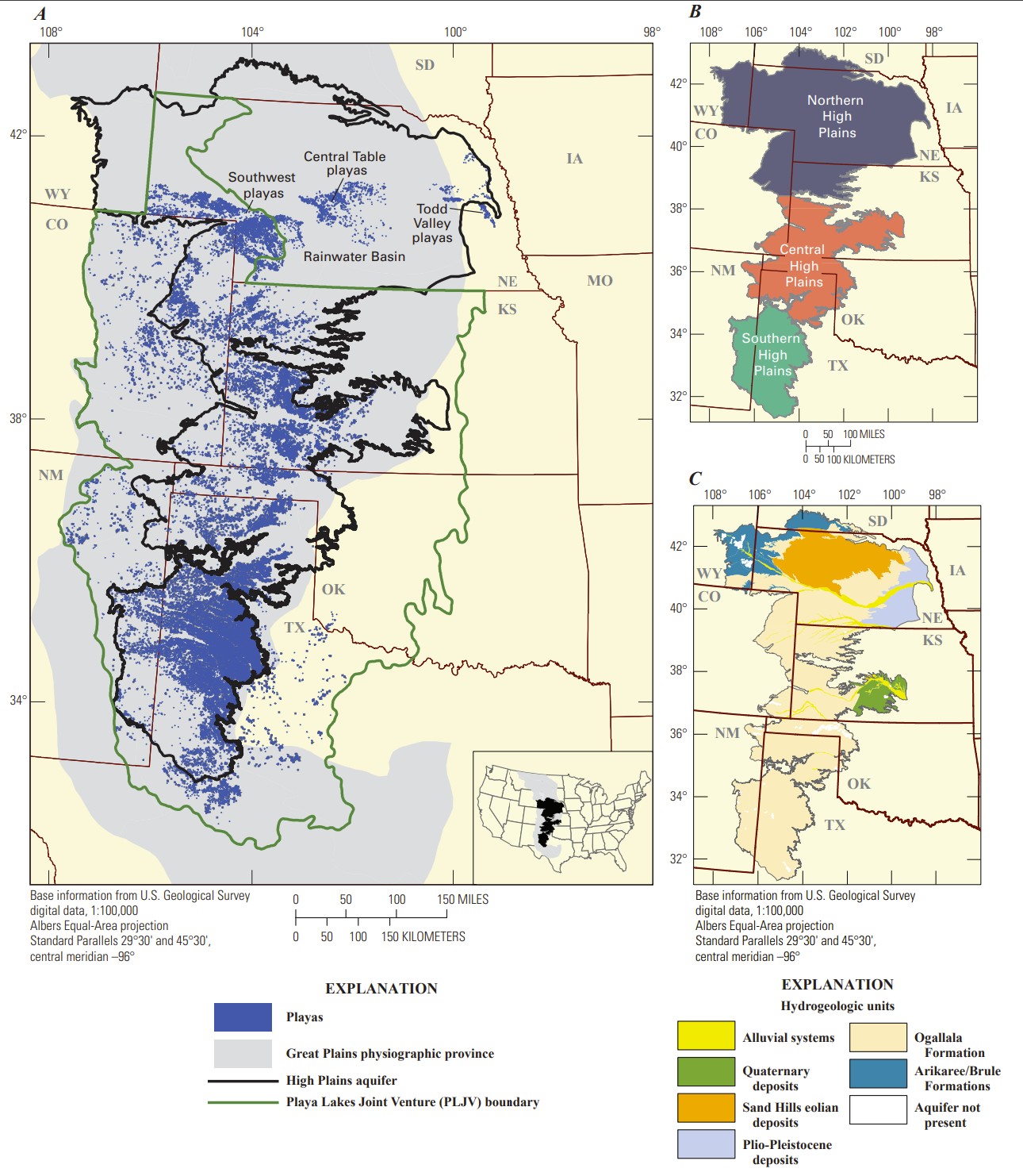
Recharge rates across the Ogallala Aquifer vary dramatically by region, ranging from as little as 0.024 inches (0.61 mm) per year in parts of Texas and New Mexico to 6 inches (150 mm) per year in south-central Kansas.1, 2 The southern High Plains—covering much of western Texas and eastern New Mexico—experiences some of the lowest recharge rates in the entire system.
The Ogallala gets recharged primarily by rainwater, but only about one inch of precipitation actually reaches the aquifer each year in the southern regions.1, 2 This extremely low recharge happens because rainfall in most of the Texas High Plains is minimal, evaporation is high, and water soaks in slowly.
Several factors limit recharge in this region. Much of the area is semiarid, with steady winds that speed up evaporation of surface water and rainfall. In many places, the aquifer sits beneath a layer of caliche—a cement-like hardpan that's practically impermeable and blocks water from filtering down into the aquifer.2 Thus, the aquifer recharge is quite low compared with other well-known Texas aquifers such as the Carrizo-Wilcox (recharge 0.5-5 in/yr) and the Gulf Coast aquifer (0.1-10 in/yr).4, 5 The amount of recharge is generally a function of the aquifer geology and regional rainfall and is not dependent on water extraction.
Playa Lakes: Critical Recharge Focal Points
Despite the generally poor recharge conditions, recent research has identified playa lakes as the primary way water gets into the Ogallala in the southern High Plains. Approximately 19,250 seasonal lakes on the Southern High Plains of Texas and New Mexico, commonly known as playas, are the main entry points for water recharging the Ogallala aquifer.6
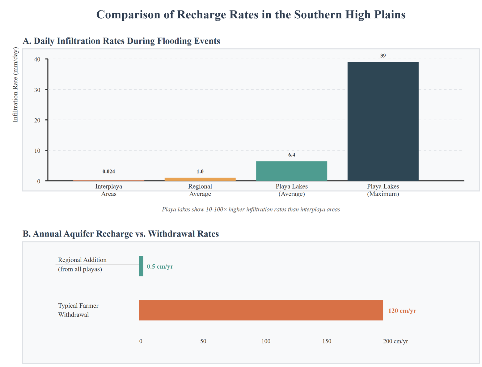
The soil in playa lakes is different and not lined with caliche, making these some of the few areas where the aquifer can actually recharge.2 Recharge rates beneath playas are substantially higher—10 to 100 times greater—than recharge rates in the areas between playas.3, 7 Studies show recharge rates beneath playas range from less than 1.0 to more than 500 mm/yr (0.04-20 in/yr), generally 1-2 orders of magnitude higher than rates beneath the surrounding landscape.8
Recent monitoring studies have provided more precise measurements of how much playas contribute. Researchers found that playa lakes overall averaged 6.4 millimeters per day (0.25 in/day) during flooding events, with maximum rates reaching approximately 39 millimeters per day and minimum rates of just 1 millimeter per day (1.5 in/day).7 When you add it all up across the region, each lake contributes about 25 centimeters (9.8 in) of water on average, which amounts to about 0.5 centimeters (0.2 in) every year added to the aquifer across the entire southern High Plains.
Hydrologic Evidence Supporting Playa-Focused Recharge
Computer modeling studies have validated the theory that recharge happens mainly through playas. The results showed that the playa-focused recharge theory makes sense hydrologically, with models showing that water table patterns under the playa-focused scenario matched real-world observations as well as or better than other approaches. These models suggest a recharge rate of 219 mm/yr (8.62 inches/yr) focused through playas across the Blackwater Draw part of the Southern High Plains and 9 mm/yr (0.354 inch/yr) for the Ogallala outcrop area.6
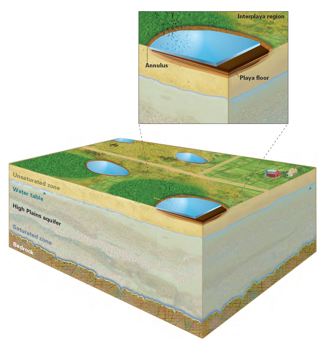
Figure 3. Principal physical features of playas include the playa floors, primarily composed of vertisols, and the annulus. The interplaya region is the land surface that surrounds playas and includes the upland setting that drains into playas. Figure from Gurdak and Roe.9
Implications for Water Management
The limited recharge capacity has significant implications for how we manage water. Enhanced playa recharge may provide a sustainable local water resource but won't substantially change the overall water budget for the Ogallala.2 The destruction of playas by farmers and development decreases the available recharge area.1 This makes protecting existing playa lakes critical for maintaining even the minimal recharge that currently occurs.
Conclusion
While the Ogallala Aquifer does experience recharge in the southern High Plains, primarily through playa lakes, the rates are extremely low compared to current pumping levels. The system essentially functions as a non-renewable resource in this region, with recharge rates measured in millimeters per year while withdrawal rates are measured in meters per year.1, 10 This fundamental imbalance between recharge and extraction makes current water use patterns unsustainable over the long term, requiring significant changes in water management and agricultural practices to extend the viable life of this critical water resource. So, does the Ogallala Aquifer recharge? Yes, it certainly does. Yet if the extraction rate is on the order of 1000 times greater than recharge, the natural recharge is just a drop in the bucket.
References
(1) Gutentag, E. D.; Heimes, F. J.; Krothe, N. C.; Luckey, R.; Weeks, J. B. Geohydrology of the high plains aquifer in parts of colorado, kansas, nebraska, new mexico, oklahoma, south dakota, texas, and wyoming; 1984. https://pubs.usgs.gov/publication/pp1400BDOI: 10.3133/pp1400B.
(2) TWDB. Ogallala aquifer. Texas Water Development Board (TWDB), 2024. https://www.twdb.texas.gov/groundwater/aquifer/majors/ogallala.asp (accessed 2025.
(3) Gurdak, J.; Roe, C. Review: Recharge rates and chemistry beneath playas of the high plains aquifer, USA. Hydrogeology Journal 2010, 18, 1747–1772. DOI: 10.1007/s10040-010-0672-3.
(4) Scanlon, B. R.; Reedy, R. C.; Strassberg, G.; Huang, Y.; Senay, G. B. Estimation of groundwater recharge to the gulf coast aquifer in texas, USA; Bureau of Economic Geology, Jackson School of Geosciences, The University of Texas at Austin, Austin, TX, 2012. https://www.twdb.texas.gov/groundwater/docs/studies/TWDB%20Gulf%20Coast%20Recharge.pdf.
(5) Scanlon, B. R.; Dutton, A.; Sophocleous, M. Groundwater recharge in texas; Bureau of Economic Geology, The University of Texas at Austin, and Kansas Geological Survey, Austin, TX, 2003. https://www.twdb.texas.gov/publications/reports/contracted_reports/doc/2000483340.pdf.
(6) Mullican, W. F.; Johns, N.; Fryar, A. E. Playas and recharge of the ogallala aquifer on the southern high plains of texas--an examination using numerical techniques. 1997.
(7) Weinberg, A.; Olden, M.; Gitz, D.; Byars, C. Playa lakes in the southern high plains: Runoff, infiltration, and recharge; Report 386; Texas Water Development Board (TWDB), Austin, TX, 2021. https://www.twdb.texas.gov/groundwater/special_projects/playa/playa_lakes.asp.
(8) White, W.; Broadhurst, W. L.; Lang, J. Ground water in the high plains of texas; Washington, D.C., 1946. https://pubs.usgs.gov/publication/wsp889FDOI: 10.3133/wsp889F.
(9) Gurdak, J.; Roe, C. Recharge rates and chemistry beneath playas of the high plains aquifer—a literature review and synthesis; Circular 1333; United States Geologic Survey (USGS), Reston, VA, 2009. https://pubs.usgs.gov/circ/1333/.
(10) Gowda, P.; Steiner, J.; Farrigan, T.; Grusak, M.; Boggess, M.; Olson, C. Agriculture and rural communities. In impacts, risks, and adaptation in the united states: Fourth national climate assessment, volume ii [reidmiller, d.R., c.W. Avery, d.R. Easterling, k.E. Kunkel, k.L.M. Lewis, t.K. Maycock, and b.C. Stewart (eds.)]. 2018; pp 391–437.